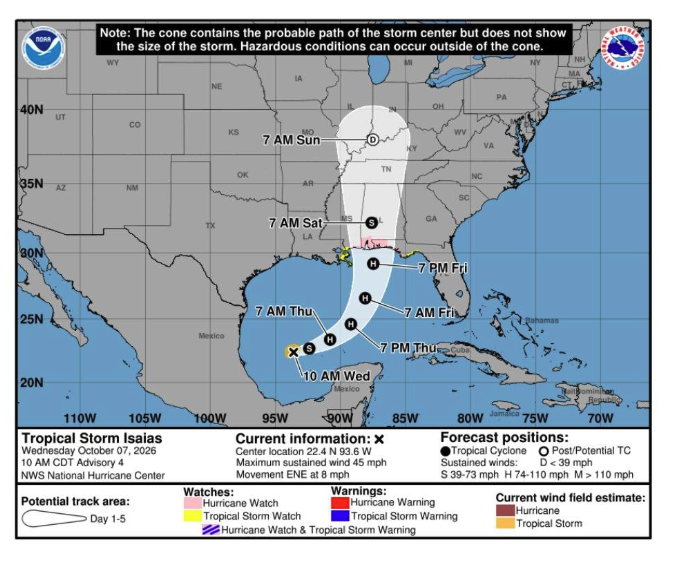
A Gulf of Mexico disturbance strengthened into Tropical Depression 9 on Tuesday, Oct. 6, after reaching 100% formation probability.
The National Weather Service Houston/Galveston confirmed the milestone, and the Galveston County Office of Emergency Management responded with an advisory urging residents, including those in League City, to stay weather-aware and monitor forecasts. The office said the system is showing increasing organization and will likely develop into a storm within a day.
The storm's projected path offers some relief for the Texas coast. Forecasts show the system staying south of Texas as it moves east, eventually turning north toward the Florida Panhandle. The National Hurricane Center said interests from the Florida Panhandle to Louisiana should closely monitor the system's progress, USA Today reported.
NWS Houston said on X that no major impacts are expected for Southeast Texas. Residents should expect gusty winds and building seas along the coast.
The jump was rapid. As recently as Sunday, Oct. 4, the system carried far lower development odds, with forecasters pegging the chance between 40% and 70% depending on the time frame. By Tuesday afternoon, the National Hurricane Center confirmed a full tropical depression had formed.
"The storm is already becoming better organized faster than expected," AccuWeather hurricane expert Nicholas Arman said, according to USA Today.
A cold front moving through Southeast Texas is the key factor keeping the storm at bay. KPRC 2 meteorologist Anthony Yanez explained that winds from the front block tropical systems from pushing north, steering them east instead. Gulf water temperatures running 84°F to 88°F are fueling the system's rapid strengthening.
FOX 26 Houston reported the depression is forecast to become Tropical Storm Isaias by Tuesday night or Wednesday morning. It could reach hurricane strength by Thursday, which would make it the first hurricane of the 2026 Atlantic season. The season had produced eight named storms and no hurricanes as of Tuesday, according to USA Today citing NOAA.
The NHC said watches or warnings could be issued on the system later Tuesday or Tuesday night. League City residents can track updates on the National Weather Service Houston/Galveston website.