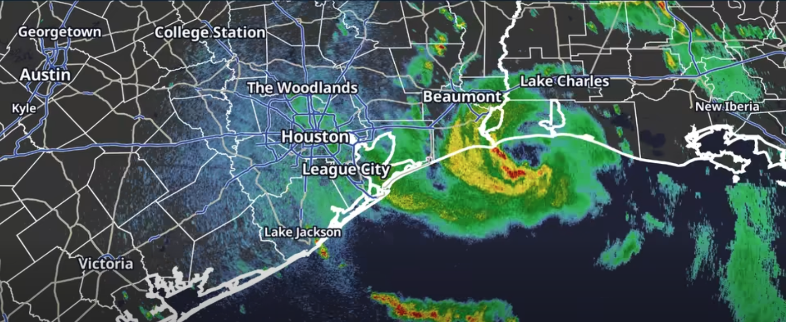
Tropical Storm Edouard bore down on the Texas-Louisiana border Tuesday, and League City sits in the storm's heaviest rain zone.
The National Weather Service (NWS) placed Galveston County under a Flood Watch through 7 a.m. Wednesday, Sept. 2. The agency forecast 3 to 5 inches of rain across Southeast Texas through Thursday, with isolated totals of 6 to 9 inches possible where bands of heavy rain stall over the same area. Rainfall rates could hit 3 to 4 inches per hour in the worst downpours, according to CW39 citing NWS data.
The greatest flood risk falls along and east of Interstate 45, which runs directly through League City. KHOU specifically named League City among the communities positioned for the greatest impacts, alongside Galveston, Baytown and Chambers County.
As of 7 a.m. Tuesday, Edouard was about 70 miles southeast of Port Arthur with maximum sustained winds of 40 mph, moving west-northwest at 8 mph, the Houston Chronicle reported. By early afternoon, NWS Houston said the storm was approaching the border with gusts up to 50 mph possible near the coast.
The heaviest rain window for League City began Tuesday afternoon and is expected to continue into Tuesday night and early Wednesday morning. Low-lying streets and areas with poor drainage face the highest risk of flooding.
State response
Gov. Greg Abbott activated the state's emergency operations center to run around the clock ahead of landfall. Twenty state agencies and 1,500 personnel were mobilized, along with rescue aircraft, swift-water rescue boats and high-water vehicles, Houston Public Media reported.
Orlando Alanis of the Texas Division of Emergency Management said at a Tuesday news conference, "This is our first big storm of the season, and I'll tell you, Texas is prepared," the Associated Press reported.
CenterPoint Energy also activated its emergency operations center and mobilized frontline workers in preparation for potential power outages.
No statements from the League City Police Department, League City Fire Department or the Galveston County Office of Emergency Management were available as of Tuesday afternoon.
What comes next
Edouard will weaken after moving inland, but tropical moisture will linger across Southeast Texas. The NWS rainfall forecast extends through Thursday, Sept. 3, and scattered heavy showers and thunderstorms are possible again Wednesday. A Slight Risk (level 2 of 4) for excessive rainfall remains in place through Wednesday, Sept. 2.
NWS Houston warned Tuesday that floodwater is difficult to see during the day and nearly impossible to spot at night. The agency urged drivers to slow down or stay off roads if possible.
Residents should never drive through flooded roadways. Turn around, don't drown. To report flooding or emergencies, call 911. For weather alerts, monitor NWS Houston at weather.gov or on X at @NWSHouston.