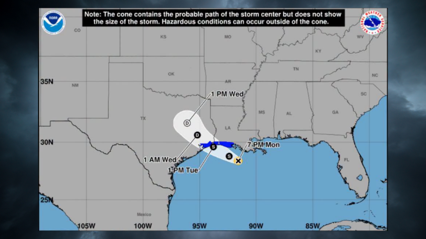
Tropical Storm Edouard is expected to make landfall along the upper Texas coast Tuesday afternoon, Sept. 1, putting League City squarely in the path of heavy rain and flash flooding.
The National Hurricane Center upgraded the system from Tropical Depression 5 on Monday evening, Aug. 31, making Edouard the fifth named storm of the 2026 Atlantic hurricane season. As of 7 p.m. Monday, the storm had maximum sustained winds of 40 mph with gusts up to 45 mph and was moving west-northwest at 6 mph. The forecast track points toward the Jefferson County coast south of Beaumont, near the Texas-Louisiana border, according to KHOU.
The National Weather Service issued a flood watch for Galveston County from 1 a.m. Tuesday through 7 a.m. Wednesday, Sept. 2. The NWS Houston/Galveston office named League City as a major population center under the watch. The NWS also designated Tuesday and Wednesday as Weather Impact Alert days.
Widespread totals of 3 to 5 inches are expected, with isolated amounts of 6 to 9 inches possible along and east of I-45, NWS Houston said on X. Rainfall rates could exceed 3 to 4 inches per hour during the most intense bands, creating flash-flood risk in urban areas.
Warnings in effect
Multiple weather alerts cover the League City area as of Tuesday morning:
- A Tropical Storm Warning is in effect for Chambers County and the Bolivar Peninsula, including High Island and Crystal Beach. Wind gusts of 40 to 60 mph are expected in Chambers County.
- A Hurricane Watch is in effect from High Island, Texas, to Cameron, Louisiana, meaning hurricane conditions are possible within the next 12 hours, according to USA Today.
- A Storm Surge Warning covers High Island to the Vermilion/Cameron Parish Line in Louisiana. Storm surge of 2 to 4 feet is forecast in that zone, with 1 to 2 feet possible on the Texas coast south toward San Luis Pass, KPRC 2 reported.
KPRC 2 meteorologist Rachel Briers forecast Edouard could be a strong 65-mph tropical storm at landfall early Tuesday afternoon. The NWS Houston/Galveston office identified League City, Galveston, Baytown, Chambers County, Liberty and Cleveland as areas likely to see some of the greatest impacts.
NWS warning coordination meteorologist Jimmy Fowler said during a Monday webinar that flash flooding is likely where the heaviest rain falls. "Where those heavier rainfall totals occur, flash flooding will be possible, especially over areas of poor drainage," Fowler said, according to the Texas Tribune.
What League City residents should know
Flash flooding is the primary threat. The heaviest rain is expected to begin Tuesday evening, with the most significant rainfall likely Tuesday night and heavy tropical downpours continuing into Wednesday morning, according to KHOU. KHOU Chief Meteorologist David Paul warned that Wednesday morning's commute could be heavily impacted by flooding and high water. The NWS placed Southeast Texas under a Level 2 of 4 risk for excessive rainfall.
Space City Weather issued a Stage 2 flood alert for areas along and east of I-45, meaning there is potential for flash flooding. Areas east of I-45 could pick up 2 to 5 inches, with higher totals possible near Mont Belvieu and points east.
Galveston County Emergency Management Coordinator Jesse Ryholt told KPRC 2 that major impacts are not expected for most of Galveston County but some areas could see significant rainfall. He said storm surge, if any, would likely be less than two feet.
As we reported Monday, CenterPoint Energy activated its Emergency Operations Center on Monday and mobilized crews across Greater Houston. Workers have been checking power lines, substations and trimming trees near power lines.
School closures and state response
Multiple Houston-area school districts canceled classes for Tuesday, including Galveston ISD, Humble ISD, Goose Creek CISD, Crosby ISD, Dayton ISD, Anahuac ISD, Channelview ISD, Galena Park ISD, Huffman ISD, Sheldon ISD and Tarkington ISD, according to the Houston Chronicle. Clear Creek ISD, which serves League City, had not announced a closure as of Monday evening.
Gov. Greg Abbott activated the state's emergency operations center to run around the clock. Twenty state agencies and 1,500 personnel were activated along with rescue aircraft, swift-water rescue boats and high-water vehicles, Houston Public Media reported.
The flood watch expires at 7 a.m. Wednesday. The system is expected to move out of the area by Wednesday midday. Residents should avoid driving through standing water.